


30 and 90 Day Forecast
30
Day
Ensemble Maps
May 20 - Long Range Summary
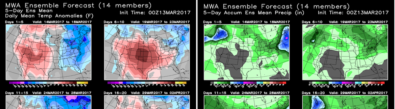
Midsummer-level temperatures across the Southern U.S. this past weekend featured more expansive triple digit heat across the southwest quadrant of the U.S. than models forecast (including central and West Texas). Not only is this early season heat currently expanding north and east to produce multiple days of the hottest temperatures of the year across the Great Lakes and Northeast starting by Tuesday (15°-20° above average), but latest model consensus is significantly slower to spread an unseasonably cold Western airmass east of the Rockies prolonging near record heat (90s) across most of the Northeast though Thursday. Even after a lead weakening cold front passes off the New England by Friday recent modeling indicates brief cooling will fail to reach seasonal levels across the Northeast (still 3°-6° above average) through next weekend (May 25-26). Another less extreme Eastern warm-up (7°-10° above average) early in the final week of May, while unseasonably cold air of Gulf of Alaska continues to drain through western Canada into the Western U.S. ensures the next week to 10-days will continue to feature severe thunderstorms focusing across the central U.S. along the boundary of sharp west-east temperature contrast. However, all extended range models have latched onto onset of lower amplitude pattern change before May is over, ejecting the final cold Western airmass of the extended series across the central and Eastern U.S. in a progressively weakening form. As such the 11-15 day period is forecast to be a transitional period of modest Eastern cooling (slightly below average at best) and early stages of progressive warming west of the Rockies. In this more summerlike low amplitude pattern warm air advancing back into the East before the end of the 1st week of June (16-20 day period) represents start of near coast to coast slightly-moderately above average temperatures and drier conditions on track to predominate June.
If your business or career depends on correctly predicting the weather, you can follow the pack or you can get ahead with MWA’s proprietary models and expert forecasts.
Model Data
Custom Tools
Consulting
Our Proprietary Forecast
For more than a decade, the most accurate weather forecasts over any time scale have come from only one source Melita Weather Associates
We owe our success to three factors:
- Our World Class Meteorologists and Climate Scientists
- The Industry’s Only Operational Climate Based Weather Model
- Specialization in Weather Products for Markets and Traders
Our Customers
Melita’s forecasts are written for professional traders and business people in Weather Impacted Business.
- Energy Traders
- Commodities Markets
- Large Scale Producers
- Governments
- Electric Utilities
- Hospitality & Recreation
Melita’s information packed forecasts assume a knowledge of weather patterns and their implications.30 and 90 day forecasts are written to deliver vital information while saving time for busy professionals.At the same time MWA forecasts have considerable detail and are backed up by our personal consultation services.